GIS aua

Schinos, Corinth - Burned Area Assessment


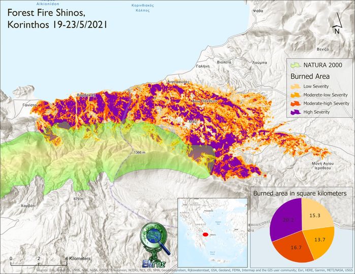
The fire (19-21/5/2021) in Schinos, Corinth, burned 65,900 hectares according to the calculations of the GIS Research Unit of the Agricultural University of Athens.
The calculations were based on Sentinel-2 satellite images. By calculating the dNBR (difference Normalized Burn Ratio) index and applying the methodology of the U.S. Geological Survey, a "burn severity map" was created. This map allows for the spatial estimation of not only the severity of the damage but also the potential future risks of flooding, landslides, and soil erosion.

More news

Συμμετοχή στο 15th International Workshop on Statistical Hydrology and Ground Water (STAHY-ICGW 2026)
Διαβάστε Περισσότερα
Νέα επιχειρησιακή υπηρεσία εκτίμησης επιφανειακής εδαφικής υγρασίας από την Ερευνητική Μονάδα GIS του ΓΠΑ στο πλαίσιο του Εθνικού Προγράμματος Μικροδορυφόρων
Διαβάστε Περισσότερα
2ο συμμετοχικό εργαστήριο του έργου Path4Med
Διαβάστε Περισσότερα
Απολογιστικό Δελτίο Τύπου
Διαβάστε Περισσότερα
Δωρεάν Τριήμερο Workshop
Διαβάστε Περισσότερα
Participation in Agrotica 2026
Διαβάστε Περισσότερα
Online Geospatial Observatory of Soil Information
Διαβάστε Περισσότερα
Best Thesis Competition
Διαβάστε Περισσότερα